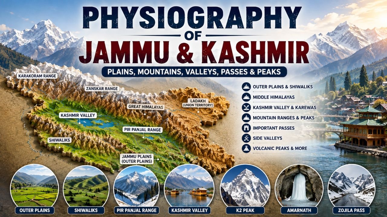
Dear aspirants, if you are preparing for JKSSB or any other competitive exams, the Physiography of Jammu and Kashmir is one of the most important topic in J&K Geography.
In this article, Exam Waves Academy provides simple and exam-focused notes and important MCQs on the location, boundaries, outer plains, Shiwaliks, Middle Himalayas, Valley of Kashmir, mountain ranges, important peaks and passes of Jammu and Kashmir.
Physiography of Jammu and Kashmir
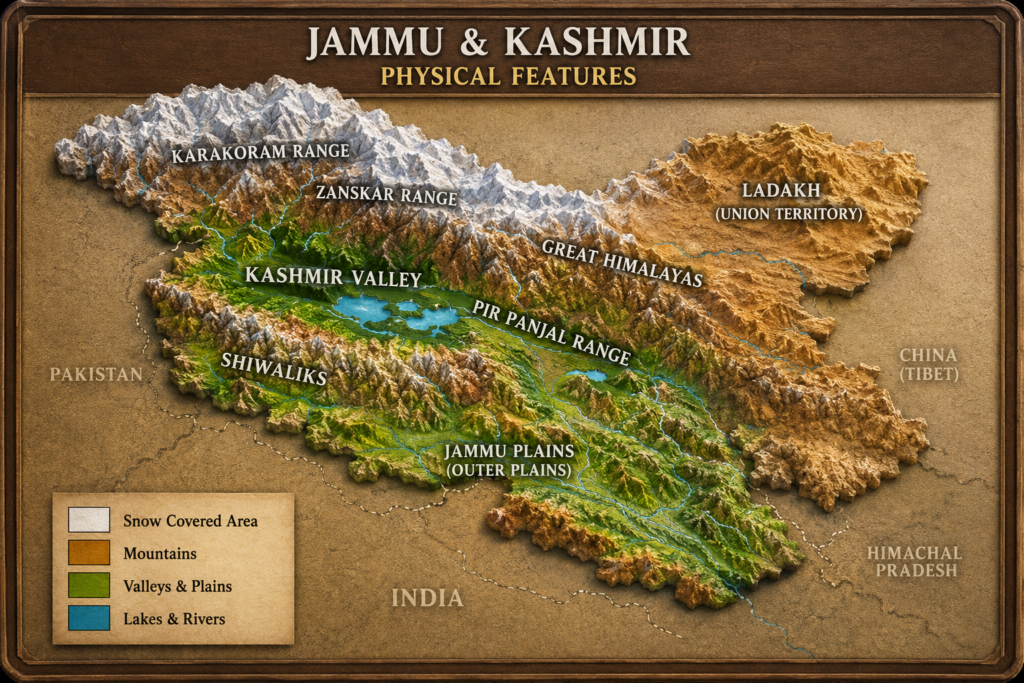
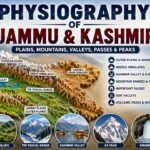
The physiography of Jammu and Kashmir is highly diverse. It includes plains, hills, valleys, mountain ranges and high-altitude areas.
The physiography of the Union Territory of Jammu & Kashmir and the Union Territory of Ladakh has been divided into different geographical regions.
Location of Jammu and Kashmir
The geographical location of Jammu and Kashmir is important for competitive examinations.
- Latitudinal extent: 32°17′ N to 36°58′ N
- Longitudinal extent: 73°26′ E to 83°30′ E
- Area: 42,241 sq. km
State Boundaries
Jammu and Kashmir shares boundaries with:
- Himachal Pradesh
- Punjab
- Ladakh
International Boundary
- Pakistan
Major Physiographic Divisions
The physical features of Jammu and Kashmir can be understood through its major geographical divisions.
1. Outer Plains
The Outer Plains form an important physiographic division of Jammu and Kashmir.
- They are a part of the Great Plains of India.
- They are locally known as Andarwah or Bajawat in J&K.
- The alluvial plains are formed by deposits of the Chenab, Tawi and Ravi rivers and their tributaries.
- They extend from the Ravi to Chenab.
- Their width ranges between 20 and 50 km.
- In the southern parts, they stretch across Akhnoor, Samba, R.S. Pura and Kathua.
- These plains are crossed by numerous seasonal torrents locally known as Khad.
- The area contains wild grass locally known as Khar or Elephant Grass.
Quick Fact
Seasonal torrents in Jammu plains → Khad
2. The Shiwaliks
The Shiwaliks are the outer hills of Jammu.
- The outer hills are known as Shiwaliks or Jammu Hills.
- They stretch from the Ravi to Jhelum.
- The slopes of the Shiwaliks adjoining the plains between the Ravi and Chenab rivers are locally known as Kandi.
- Important longitudinal valleys of the outer zone are called Duns.
Examples include:
- Udhampur
- Basholi
- Lakes such as Mansar and Surinsar are situated in the Shiwalik range.
Kandi
The Kandi region is:
- Hilly
- Characterised by numerous torrents
- Associated with scarcity of water
3. Middle Himalayas
The Middle Himalayas are locally known as Pahar.
- They are also known as the Lesser or Pir Panjal Range.
- It is described as the longest and westernmost range of the region.
- It lies between the Ravi in the east and Poonch in the west.
- Its width ranges from 10 to 60 km.
Important Peaks
- Seusset Peak
- Mata Vaishno Devi is situated on the peak of Trikuta Hills of the Lesser Himalayas.
In the Middle Himalayas, small grassy lands or slopes are locally known as:
- Marg
- Gulmarg
4. Valley of Kashmir
The Valley of Kashmir is one of the most important physical features of Jammu and Kashmir.
- The valley is oval-shaped.
- Its borders are filled with deposits of alluvial and lacustrine material called Karewas.
- Karewas are locally known as Wudar, meaning elevated tableland.
- Karewas are also found in the Bhaderwah Valley of the Jammu region.
- Saffron is cultivated on Karewas at Pampore.
Important Exam Combination
Karewas → Wudar → Elevated tableland → Saffron cultivation at Pampore
Side Valleys of Kashmir
Important side valleys include:
| Valley/Route | Location |
|---|---|
| Lidder | Anantnag to Pahalgam |
| Sind | Ganderbal to Zojila Pass |
| Lolab | Kupwara – Valley of Love |
Mountain Ranges and Passes
Mountains form an important part of the geography of Jammu and Kashmir and Ladakh.
Karakoram Range
- It is part of Ladakh UT.
- It lies to the north of the Himalayas.
- K2 (Godwin Austen) is its highest peak.
- The Gasherbrum and Masherbrum ranges lie here.
- Siachen and Biafo glaciers are located in this region.
Important Passes
- Karakoram Pass
- Nubra Pass
Zanskar Range
The Zanskar Range is another important mountain range.
- It is part of Ladakh UT.
- It lies to the north of the Himalayas.
- It separates Kashmir from Ladakh.
- Its average height is around 6,000 metres.
- It prevents south-west cold winds from reaching Kashmir.
- Kamet is mentioned as its highest peak.
Important Passes
- Zoji La
- Poat
- Drang-Drung Glacier is located in this range.
- The range also divides the Zanskar region from the Ladakh region.
Pir Panjal Range
The Pir Panjal is described as the largest range of the Lesser Himalayas.
- It lies south of the Himalayas.
- It separates Kashmir Valley from Jammu region.
- The Galyat Mountains lie in this region.
- Deo Tibba and Indrasan are peaks of the Pir Panjal Range.
- Gulmarg lies in this range.
Important Passes of Pir Panjal
- Haji Pir – Uri and Poonch
- Banihal
- Sinthan – Kashmir to Kishtwar
- Pir Panjal Pass – connects Kashmir with Rajouri
Nun Kun
Nun Kun is a series of important peaks.
- Nun – 7,135 metres, mentioned as the tallest peak of J&K.
- Kun – 7,077 metres, located in Ladakh.
- They lie between the Ladakh and Kashmir border.
- To reach Leh, one has to cross Baralacha Pass from Kullu.
Apharwat
Apharwat is an important mountain feature associated with Gulmarg.
- It is in Baramulla district.
- Height: 4,390 metres above sea level
- It spreads in the Gulmarg Valley of the Pir Panjal Range.
- Alpather Lake lies on its peak.
- Nullah Ningal originates from the lake and meets Wular Lake.
Harmukh Mountains
- Located in Ganderbal district.
- Height: 5,142 metres above sea level.
Tosamaidan
Tosamaidan is an important geographical feature.
- It remains covered with snow throughout the year.
Amarnath Mountain
- Located in Ganderbal district.
- Elevation: 5,372 metres.
- One has to cross Mahagunas Pass to reach Shri Amarnath.
Gwashram
- Gwashram is situated in the Lidder Valley towards Pahalgam.
- Kolai Glacier lies on it.
- Sheeshnag originates from it.
Volcanic Peaks
Two volcanic peaks are mentioned:
Soyamji
- Located north of Machipora (Handwara).
- It erupted in 1934.
- It is now dormant.
Karawa Peak
- Located near Pahalgam.
- It is now dead.
Important Passes
Some important mountain passes are:
| Pass | Important Association |
|---|---|
| Banihal | Kashmir and Jammu |
| Zojila | Srinagar and Leh |
| Karakoram | India and China |
| Hypsar | Poonch and Uri |
| Margin Pass | Warm Valley to Kashmir |
| Munwar | Near Rajouri |
| Haji Pir | Uri and Poonch |
| Sinthan | Kashmir and Kishtwar |
| Pir Panjal Pass | Kashmir and Rajouri |
| Mahagunas Pass | Route towards Shri Amarnath |
Important Note on Nanga Parbat
Nanga Parbat, locally known as Diamer, is described as the westernmost major peak of the Himalayas.
Quick Revision Table
| Topic | Important Fact |
|---|---|
| Area of J&K UT | 42,241 sq. km |
| Outer Plains | Andarwah/Bajawat |
| Seasonal torrents | Khad |
| Outer Hills | Shiwaliks/Jammu Hills |
| Shiwalik slopes | Kandi |
| Longitudinal valleys | Duns |
| Middle Himalayas | Pahar |
| Mata Vaishno Devi | Trikuta Hills |
| Small grassy slopes | Marg |
| Kashmir Valley | Oval-shaped |
| Karewas | Wudar/Elevated tableland |
| Saffron on Karewas | Pampore |
| Lolab | Valley of Love |
| Karakoram highest peak | K2 |
| Pir Panjal | Separates Kashmir Valley from Jammu |
| Nun | 7,135 m |
| Apharwat | 4,390 m |
| Harmukh | 5,142 m |
| Amarnath Mountain | 5,372 m |
| Mahagunas Pass | Route to Shri Amarnath |
| Zojila | Srinagar–Leh |
| Banihal | Kashmir–Jammu |
| Nanga Parbat | Also called Diamer |
Conclusion
The Physiography of Jammu and Kashmir includes diverse geographical features ranging from the Outer Plains and Shiwaliks to the Pir Panjal, Kashmir Valley and high mountain regions.
For JKSSB exams, students should pay special attention to Karewas, Kandi, Duns, mountain ranges, peaks, valleys and passes, because these facts are suitable for direct, statement-based and matching-type questions.
Important MCQ’s on Physiography of Jammu and Kashmir for all Competitive Exams
Q1. Consider the following statements regarding the geographical location of Jammu and Kashmir:
- Its latitudinal extent is 32°17′ N to 36°58′ N.
- Its longitudinal extent is 73°26′ E to 83°30′ E.
- The area of J&K UT is 42,241 sq. km.
- It shares an international boundary with Nepal.
Which of the statements given above are correct?
A) 1, 2 and 4 only
B) 1, 2 and 3 only
C) 1, 3 and 4 only
D) 2, 3 and 4 only
Answer: B
Q2. Match the following geographical terms with their correct descriptions:
| List-I | List-II |
|---|---|
| A. Khad | 1. Elevated tableland |
| B. Kandi | 2. Seasonal torrent |
| C. Dun | 3. Shiwalik slope adjoining plains |
| D. Wudar | 4. Longitudinal valley |
Select the correct answer:
A) A-2, B-3, C-4, D-1
B) A-3, B-2, C-1, D-4
C) A-4, B-1, C-3, D-2
D) A-1, B-4, C-2, D-3
Answer: A
Q3. Consider the following statements regarding the Outer Plains of Jammu and Kashmir:
- They form a part of the Great Plains of India.
- They are locally known as Andarwah or Bajawat.
- Their alluvial deposits are mainly associated with the Chenab, Tawi and Ravi rivers and their tributaries.
- They extend from the Jhelum to the Indus.
Which of the statements given above are correct?
A) 1, 2 and 4 only
B) 1, 3 and 4 only
C) 1, 2 and 3 only
D) 2, 3 and 4 only
Answer: C
Q4. Which of the following statements correctly describe the Outer Plains?
- Their width varies from about 20 to 50 km.
- Their southern part stretches across Akhnoor, Samba, R.S. Pura and Kathua.
- Numerous seasonal torrents in these plains are locally called Khad.
- Elephant Grass is locally known as Marg.
Select the correct answer:
A) 1, 2 and 3 only
B) 1, 2 and 4 only
C) 1, 3 and 4 only
D) 2, 3 and 4 only
Answer: A
Q5. Consider the following statements regarding the Shiwaliks:
- The outer hills are also called Shiwaliks or Jammu Hills.
- They stretch from the Ravi to Jhelum.
- The slopes adjoining the plains between Ravi and Chenab are locally called Kandi.
- Kandi is characterised by abundant perennial water resources.
Which of the statements given above are correct?
A) 1, 2 and 4 only
B) 1, 2 and 3 only
C) 1, 3 and 4 only
D) 2, 3 and 4 only
Answer: B
Q6. Match the following features with their correct geographical associations:
| List-I | List-II |
|---|---|
| A. Mansar and Surinsar | 1. Middle Himalayas |
| B. Kandi | 2. Shiwalik Range |
| C. Pahar | 3. Shiwalik slopes adjoining plains |
| D. Trikuta Hills | 4. Mata Vaishno Devi |
Select the correct answer:
A) A-3, B-2, C-4, D-1
B) A-1, B-4, C-2, D-3
C) A-2, B-3, C-1, D-4
D) A-4, B-1, C-3, D-2
Answer: C
Q7. With reference to the Middle Himalayas, consider the following statements:
- They are locally known as Pahar.
- They are also associated with the Lesser or Pir Panjal Range.
- Their width ranges approximately from 10 to 60 km.
- Mata Vaishno Devi is situated on the Karakoram Range.
Which of the statements given above are correct?
A) 1, 2 and 3 only
B) 1, 2 and 4 only
C) 1, 3 and 4 only
D) 2, 3 and 4 only
Answer: A
Q8. Consider the following statements regarding the Valley of Kashmir:
- The valley is oval-shaped.
- Its border deposits of alluvial and lacustrine material are called Karewas.
- Karewas are locally known as Wudar.
- Wudar refers to deeply cut river gorges.
Which of the statements given above are correct?
A) 1, 2 and 4 only
B) 1, 3 and 4 only
C) 2, 3 and 4 only
D) 1, 2 and 3 only
Answer: D
Q9. Match the following valleys/features with their correct locations or associations:
| List-I | List-II |
|---|---|
| A. Lidder | 1. Kupwara |
| B. Sind | 2. Pampore |
| C. Lolab | 3. Anantnag–Pahalgam |
| D. Saffron cultivation on Karewas | 4. Ganderbal–Zojila |
Select the correct answer:
A) A-4, B-3, C-2, D-1
B) A-3, B-4, C-1, D-2
C) A-1, B-2, C-4, D-3
D) A-2, B-1, C-3, D-4
Answer: B
Q10. Consider the following statements regarding the Karakoram Range:
- It is a part of Ladakh UT.
- It lies to the north of the Himalayas.
- K2 (Godwin Austen) is its highest peak.
- The Mansar and Surinsar lakes are situated in this range.
Which of the statements given above are correct?
A) 1, 2 and 3 only
B) 1, 2 and 4 only
C) 1, 3 and 4 only
D) 2, 3 and 4 only
Answer: A
Q11. Which of the following combinations are correctly associated with the Karakoram Range?
- K2 — Godwin Austen
- Gasherbrum and Masherbrum — Peaks/ranges of the region
- Siachen and Biafo — Glaciers
- Karakoram and Nubra — Passes
Select the correct answer:
A) 1 and 3 only
B) 2 and 4 only
C) 1, 2 and 3 only
D) 1, 2, 3 and 4
Answer: D
Q12. Consider the following statements regarding the Zanskar Range:
- It is a part of Ladakh UT.
- It separates Kashmir from Ladakh.
- Its average height is approximately 6,000 metres.
- It allows south-west cold winds to freely enter Kashmir.
Which of the statements given above are correct?
A) 1, 2 and 4 only
B) 1, 3 and 4 only
C) 1, 2 and 3 only
D) 2, 3 and 4 only
Answer: C
Q13. Match the following passes with their correct connections:
| List-I | List-II |
|---|---|
| A. Banihal | 1. Srinagar and Leh |
| B. Zojila | 2. Kashmir and Rajouri |
| C. Sinthan | 3. Kashmir and Jammu |
| D. Pir Panjal Pass | 4. Kashmir and Kishtwar |
Select the correct answer:
A) A-3, B-1, C-4, D-2
B) A-1, B-2, C-3, D-4
C) A-4, B-3, C-2, D-1
D) A-2, B-4, C-1, D-3
Answer: A
Q14. Consider the following statements regarding the Pir Panjal Range:
- It is described as the largest range of the Lesser Himalayas.
- It separates the Kashmir Valley from the Jammu region.
- Deo Tibba and Indrasan are peaks associated with this range.
- Gulmarg is situated in the Karakoram Range.
Which of the statements given above are correct?
A) 1, 2 and 4 only
B) 1, 2 and 3 only
C) 1, 3 and 4 only
D) 2, 3 and 4 only
Answer: B
Q15. Match the following mountain features with their correct facts:
| List-I | List-II |
|---|---|
| A. Nun | 1. 5,142 metres |
| B. Kun | 2. 4,390 metres |
| C. Apharwat | 3. 7,135 metres |
| D. Harmukh | 4. 7,077 metres |
Select the correct answer:
A) A-4, B-3, C-1, D-2
B) A-3, B-4, C-2, D-1
C) A-2, B-1, C-4, D-3
D) A-1, B-2, C-3, D-4
Answer: B
Q16. Consider the following statements regarding Apharwat:
- It is located in Baramulla district.
- Its elevation is approximately 4,390 metres above sea level.
- It spreads over the Gulmarg Valley in the Pir Panjal Range.
- Wular Lake is situated directly on its peak.
Which of the statements given above are correct?
A) 1, 2 and 4 only
B) 1, 3 and 4 only
C) 2, 3 and 4 only
D) 1, 2 and 3 only
Answer: D
Q17. Which of the following statements regarding Apharwat and its drainage are correct?
- Alpather Lake lies on Apharwat Peak.
- Nullah Ningal originates from Alpather Lake.
- Nullah Ningal ultimately meets Wular Lake.
- Sheeshnag originates from Alpather Lake.
Select the correct answer:
A) 1, 2 and 3 only
B) 1, 2 and 4 only
C) 1, 3 and 4 only
D) 2, 3 and 4 only
Answer: A
Q18. Match the following geographical features with their correct associations:
| List-I | List-II |
|---|---|
| A. Harmukh | 1. Mahagunas Pass |
| B. Amarnath Mountain | 2. Kolai Glacier |
| C. Gwashram | 3. Ganderbal, 5,142 m |
| D. Tosamaidan | 4. Remains snow-clad throughout the year |
Select the correct answer:
A) A-2, B-3, C-4, D-1
B) A-1, B-4, C-3, D-2
C) A-3, B-1, C-2, D-4
D) A-4, B-2, C-1, D-3
Answer: C
Q19. Consider the following statements regarding the volcanic peaks:
- Soyamji is situated north of Machipora in Handwara.
- Soyamji erupted in 1934 and is now dormant.
- Karawa Peak is located near Pahalgam and is described as dead.
- Both Soyamji and Karawa Peak are currently active volcanoes.
Which of the statements given above are correct?
A) 1, 2 and 3 only
B) 1, 2 and 4 only
C) 1, 3 and 4 only
D) 2, 3 and 4 only
Answer: A
Q20. Consider the following pairs:
- Nanga Parbat — Diamer
- Lolab — Valley of Love
- Mahagunas Pass — Route towards Shri Amarnath
- Mata Vaishno Devi — Trikuta Hills
Which of the pairs given above are correctly matched?
A) 1, 2 and 3 only
B) 1, 3 and 4 only
C) 2, 3 and 4 only
D) 1, 2, 3 and 4
Answer: D